HMS Culloden (Culloden Point, NY)
The HMS Culloden is a Revolutionary War era British warship that sank in a winter storm on January 23, 1781 while attempting to repel a French fleet of 13 frigates and 7 “ships-of-the-line” from entering Gardiner’s Bay to aid the Colonial forces.
Experience the thrill of diving on the historical HMS Culloden!
Access Information | Driving Directions
History
The HMS Culloden was part of a British fleet of 14 warships stationed in Gardner’s Bay. The Culloden and three other ships were instructed to patrol the area between Montauk Pt. and the Nantucket Shoals, and to defend against any French ships trying to enter this area. Essentially, they formed a blockade.
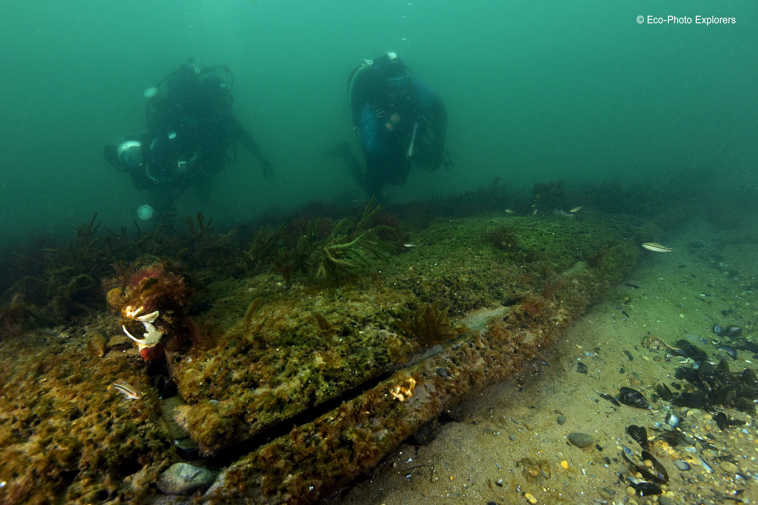
The HMS Culloden came to rest in about 15-25 feet of water just off shore at a place called Will’s Point, now named Culloden Point, in Fort Pond Bay, just west of Montauk Point. She had become disoriented in the raging winter gale.
The remains of this historic shipwreck have been lying in the shifting sands of Fort Pond Bay for over 200 years, often completely buried, and sometimes with just a few timbers exposed to indicate the wreck site.
Divers who wish to dive the wreck find that, although shallow, it is a difficult wreck to locate. Despite this, the wreck of the HMS Culloden remains one of Long Island’s premier dive targets.
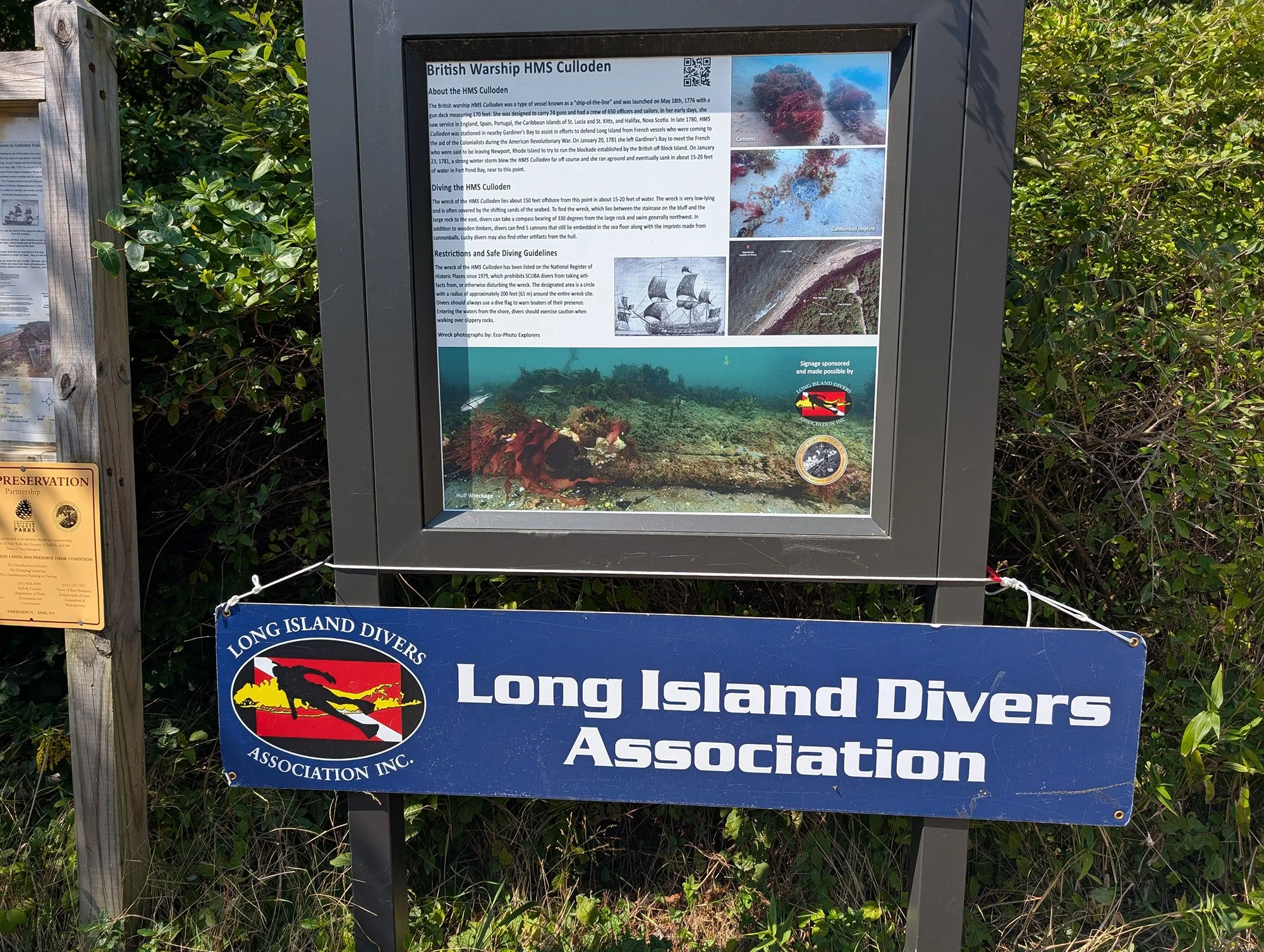
Over the years, a number of artifacts from the wreck have been professionally recovered and are displayed at the East Hampton Town Marine Museum. A large canon, copper sheathing and a section of the sailing ships’ rudder are all preserved and offered for view to the public.
Interpretive Sign Commissioned by LIDA
Protecting the Culloden:
The HMS Culloden is a genuine part of local maritime history and is on the National Registry of Historic Places and is protected by law from damage and salvage.
Since 1979 the wreck site has been listed on the National Register of Historic Places, which prohibits SCUBA divers from taking artifacts from, or otherwise disturbing the wreck. The designated area is a circle with a radius of approximately 200 feet (61 m).
Whatever you find or see there must be left in place. It is illegal to damage the wreck site in any way or to remove anything from the site.
Parking:
The dirt parking lot adjacent to the trailhead that leads to the dive site is small and can only accommodate a few vehicles. It is very strongly advised that divers seek to carpool wherever possible to reduce the number of vehicles in the lot. When parking, please try to park so as not to block others from leaving. It is possible that the site might be used by fisherman and others and blocking their vehicles is not appropriate.
Facilities:
There is no facilities at the site (e.g., food, restrooms, etc.). LIDA encourages divers to use the public restrooms on west Lake Drive near Gosman’s Dock before going to the site.
Dive Briefing:
Like all Long Island dive sites, conditions may vary greatly at the location. A few words of caution: The January 23, 1781 Wreck of the Revolutionary War British War Ship is low-lying and sometimes is completely covered in sand. Entry and exit can be treacherous as the water is very shallow to begin with and the bottom is covered with numerous slick, seaweed covered rocks that makes footing difficult. (This is why it’s best to dive at high tide).
Please use caution!
The wreck is pretty broken up and is spread out over a large area over a sandy bottom. Most of the artifacts have been recovered, but lucky divers may still be able to find some of the timbers and possibly artifacts that were not recovered.
The wreck is no deeper than 15-18 feet so plan accordingly. To locate the wreck take a compass heading of 330 degrees from the large boulder on the beach.
Look, take photos, but don't take anything!
Remember, this site is on the National Registry of Historic Places and is protected by law from damage and salvage.

Large boulder on the beach.
Directions to Dive Site
Take the Long Island Expressway (I-495) E toward Riverhead. Take exit 70 toward NY-27/Alt Route/Montauk, proceeding to Sunrise Hwy. Turn right onto Eastport Manor Rd. Continue onto County Rd 111, and merge onto Sunrise Hwy. E (NY-27). Turn left onto Edgemere Street, which will turn onto Flamingo Ave. Turn left onto Culloden Place, turn left onto Blackberry Drive, turn right onto Pine Tree Drive, then left onto Soundview Drive, which becomes a dirt road (Rd B). Continue about a 1/4 mile and turn right onto another dirt road (no name) take it to the end and park.
GPS Coordinates: 41°04'13.3"N 71°57'29.9"W
Articles & Images
Wreck of the HMS Culloden: An East Coast Shore Dive into History
California Diver Magazine (Posted: 6/6/2021)
Text and Photography by Eco-Photo Explorers
Article: PDF Version | Online
Dive Site Staircase
Recognizing that the wreck of the HMS Culloden is of interest to local divers, the Long Island Divers Association (LIDA) championed a successful effort many years ago to secure diver shoreline access to the site and also arranged for the construction of a staircase to the site along a steep bluff.

Sadly, this staircase was destroyed with subsequent hurricanes and winter storms. Diver access to the site effectively was washed away with it. In fact, LIDA has been in contact with the Town of East Hampton in 2017 and 2018 advocating for the rebuilding of the stairway down to the beach where the old shipwreck can be accessed.
Now, efforts by LIDA to regain diver access to the wreck of the Culloden have culminated in an announcement that the town of East Hampton has rebuilt the staircase!


